
Aeronautical Maps – enhanced digitalization
The Challenge
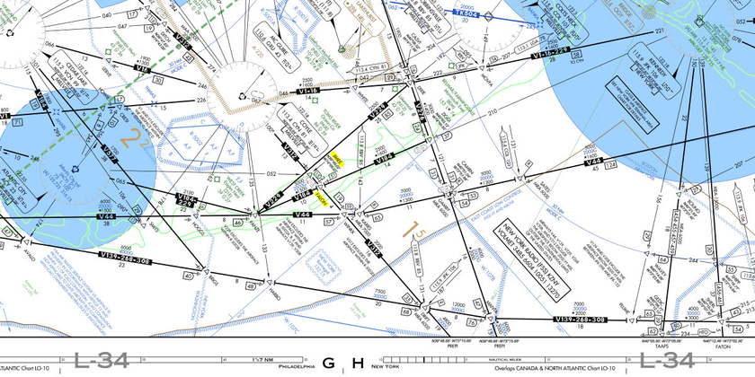
In the aviation domain, the reliance on aeronautical maps by operational stakeholders is indispensable for crafting efficient and secure flight routes. However, the exponential growth in aeronautical data has given rise to a significant challenge. Traditional static maps, while rich in information about airspace structure, navigation aids, terrain, and obstacles, struggle to maintain information priority standards, useability, interactiveness, regulatory standards and succumb to information clutter. This poses a real concern for aviation professionals, as the sheer volume of data presented in a fixed format can be overwhelming, making it difficult to discern critical details amidst the complexity.
To address this challenge, there is a growing need for an interactive Aeronautical digitalized map. Such a dynamic solution would empower users, to selectively visualize pertinent information. By offering a customizable interface, this digitalized map would enhance clarity and streamline the interpretation of extensive aeronautical data. This transformative approach not only mitigates the challenges posed by static maps but also presents an opportunity to revolutionize the way operational stakeholders engage with and extract meaningful insights from the ever-expanding realm of aeronautical information, ultimately leading to safer and more efficient flight planning.
Our Role
Cognitive Navigation’s expertise in aviation domain demonstrated its commitment to excellence by providing Aeronautical and analytical expertise throughout the development of internationally competitive interactive aeronautical digital maps. We conducted in-depth analysis of complex aeronautical data to ensure accuracy and adherence to regulatory and industry standards. Our team spearheaded the creation of new functionalities, introducing innovative features that enhanced user experience and flight planning efficiency.
Additionally, we generated new ideas to address challenges such as data clutter and readability issues. The team proposed solutions to optimize map displays, streamline information presentation, and improve overall usability.
Cognitive Navigation’s GIS (Geographic Information System) specialists proved crucial in the development process. The team harnessed advanced GIS technologies to organize, analyse, and visualize spatial data effectively. This expertise facilitated the seamless integration of aeronautical maps with other Flight Operational systems and provided a foundation for the creation of adynamic, interactive mapping platform.
By combining analytical prowess, innovative thinking, and GIS expertise, Cognitive Navigation’s Aeronautical team not only met but exceeded the needs. The resulting internationally competitive digital aeronautical maps set a new standard in precision, real-time updates, and user-friendly functionality for global flight planning.
Our Expertise
- Aeronautical Data Analysis
- Information gathering and sourcing
- Geographic Information System (GIS) service
- Aeronautical Information Service
- Process development
- Root Cause Analysis
- Research and Development